Hawaiian Mid-Summer Surf Forecast 2023: Riding the El Niño Wave!
Riding the El Niño Wave!
Weather Condition
In the insightful article by Schaler Perry, we delve into the crucial details of the recent weather forecast, specifically focusing on the Hawaiian mid-summer outlook for 2023. As we approach this vibrant season, all eyes are on the potential impact of the El Niño phenomenon, a primary driver shaping surf prospects for the back half of the year. Perry's expert analysis sheds light on the implications of the building El Niño event and how it may influence wave patterns, storm tracks, and tropical systems in the region. Continue reading to explore the intriguing possibilities that lie ahead, offering surf enthusiasts and weather enthusiasts alike a glimpse into the dynamic interplay between nature and the waves.

Photo from Hawaii Aloha Travel
From Schaler Perry's article, it is stated there that during the current season, the main source of Hawaiian-bound swell lies between the east coast of New Zealand and French Polynesia. Swells from the Tasman Sea are blocked by Fiji and surrounding islands, but storms to the east of French Polynesia generate SSW-S swells that affect the region.
In early May, a powerful storm off New Zealand produced a 20-foot-plus swell at Teahupo'o, leading to the largest surf on Oahu's South Shore for the entire year. Following this, a weeks-long period of swell from an unusual S-SSE approach angle occurred due to persistent storms in the eastern part of the basin and high pressure in the southwest. This weather pattern created an elongated swell that continued into the latter half of the month.
The El Niño Effect
In the article, he then discusses the impact of the building El Niño event on surf prospects for the latter half of the season. The outlook for the year remains uncertain, with some climate models predicting a robust El Niño event while others are more conservative.
The ideal conditions for Hawaiian-bound Southern Hemisphere swell involve high-pressure in the Tasman Sea as low pressure passes below New Zealand and towards French Polynesia in the southwest Pacific.
Currently, weak El Niño conditions are present, but a stronger event could lead to changes in the South Pacific storm track and an increased likelihood of an active Eastern Pacific tropical season.
Past summers transitioning to El Niño show a pattern of July being a slump month for South Shores, but there is optimism for active surf in August and September based on previous years.
El Niño may bring a greater chance of tropical systems reaching the central Pacific and passing closer to the Hawaiian islands, resulting in notable surf on the North and windward shores in the coming months.
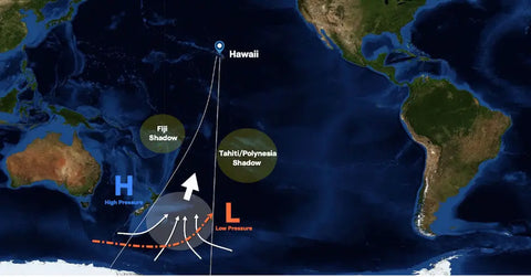
Photo from Schaler Perry's article
Weather Transition
Late June and early July marked a period of transition in the South Pacific, leading to a confused storm track that will persist for a few more weeks. However, a favorable pattern for Hawaiian surf is on the horizon, with a more active run of storms expected to lift from below New Zealand into the central and eastern South Pacific. This pattern is likely to settle in by the end of July.
Looking ahead to the rest of the summer, the general pattern indicates more storms passing through the sweet spot in the South Pacific, which bodes well for Hawaiian surf. Although the season started unconventionally, it is expected to finish fruitfully, providing plenty of rideable to fun days in the two-to-four-foot range, but fewer days with overhead waves. Typical summer conditions will persist but may be occasionally disrupted by passing tropical systems, which can bring strong winds, heavy rain, flooding, and periods of quality surf.
Currently, weak El Niño conditions are present, but a stronger event could lead to changes in the South Pacific storm track and an increased likelihood of an active Eastern Pacific tropical season.
Past summers transitioning to El Niño show a pattern of July being a slump month for South Shores, but there is optimism for active surf in August and September based on previous years.
El Niño may bring a greater chance of tropical systems reaching the central Pacific and passing closer to the Hawaiian islands, resulting in notable surf on the North and windward shores in the coming months.
Let me know if this accurately summarizes Perry's projections on how El Niño may impact Hawaiian waves!
Full article
Interested in more in El Niño blogs? We got you covered! You can visit in this page