El Nino Finally Kicks in—Just in Time for the Holidays
Why El Nino Matters This Christmas
During major El Nino years, there’s a general active pattern in the Pacific that kicks in right around Christmas. In fact, that’s why the weather phenomenon is called El Nino—because the people of Peru noticed that it happens near Christmas and they associate it with the Nativity (“El Nino” means “the boy” or “the baby boy” in Spanish, and in this case refers to the Christ child).
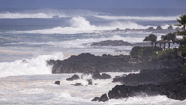
Waimea Bay (@erikkabik)(Erik Kabik/@erikkabik)
If you are wondering why this is relevant, you have probably missed out on two important facts. The first is that we are coming into what appears to be a moderate to strong El Nino, and the second is that it’s Christmas this week. And wouldn’t you know, two days after Christmas, Hawaii is about to get hammered by the first of an almost endless succession of storms. In other words, here comes El Nino!
Big Swells Lining Up Through Early January
While this swell train is better set up for the West Coast, Hawaii will enjoy numerous back-to-back-to-back pulses in the last week of December and first week of January, with the first XL swell filling in on the 27th. Peaking at around 13 to 14 feet at 15 seconds, this should be a fun swell for small Waimea, and possibly a few sessions at the outer reefs if the wind stays as light as forecasted. This initial pulse is followed by a larger swell on the evening of the 28th and into the 29th, which could peak at as big as 16 feet at 16 seconds—a legit XL swell that should have a few sets in the 20-foot range.
On the back end of both of these swells, size should stay in the 8- to 10-foot range, which means no shortage of quality waves at Pipeline and Sunset—especially if the wind goes ESE, which is currently forecasted. Then, just in time for New Years, when everyone is surfed out and ready to party, a third swell will fill at around 10 feet at 16 seconds—once again, big enough to light up Pinballs/Baby Waimea, Sunset, and Pipe.
You’d think that three swells through two holidays would be enough to wear out El Nino, but the most recent forecasts actually show the biggest swell of the run lining up for January 2—so make sure you don’t party too hard for New Years. Current predictions are calling for 16 feet at 19 seconds on Tuesday, January 2—and if that swell comes in even 10 to 20 percent above forecast (as most of the swells so far this winter have done), it could easily turn into an Eddie-caliber event. While the wind is currently looking a bit adverse with its northeast angle, that shouldn’t stop the North Shore’s hardest chargers from taking over Waimea, where the waves could be in the solid 18- to 20-foot+ range.
Once that XXL behemoth clears out, there is still a consistent run of double-overhead+ swell lining up for the second week of January. In other words, after a three-week hiatus that has seen a lot more wind than swell on the North Shore, winter is back in full swing and El Nino is officially here. It’s time to get wet!
More to Read🔎📚
HOW EL NINO MIGHT BE AFFECTING SHARK BEHAVIOR NEAR OAHU THIS YEAR